Search Term Record
Metadata
Search Terms |
Demolished buildings, lost buildings |
Related Records
-
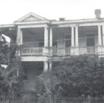
100 Broad Street - ca. 1950
B&W photograph (scan) of 100 Broad Street, street (front) elevation. The building was demolished ca. 1953 for the construction of the American Mutual Life Insurance building, which itself was later demolished for the construction of the Judicial Center. Courtesy of the Fairfield County Historical Museum.
Record Type: Photo
-
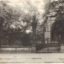
101 St. Philip Street Gate - ca. 1920
Scans of photograph of the gate at the front of 101 St. Philip Street (Samuel G. Stoney House), street (front) elevation (now gone). Photo album page annotation: Stoney Residence - Vanderhorst and St. Philip Streets [post-it note in album states "this is gone"]. Written on verso of photo: February 23/20.
Record Type: Photo
-
102 Beaufain Street - 1964
Eight B&W photographs of 102 Beaufain Street, dated April 15, 1964. The house was demolished in 1965 and two townhouses were constructed on the site ca. 1975. a: Front elevation. b: Front door. c: Column at corner of piazza. d: Door to outbuilding. Address 10½ Beaufain. e: Arched interior door and doorway. f: Ceiling medallion.* g: Crown molding.* h: Detail of interior door surround keystone.
Record Type: Photo
-
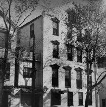
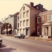
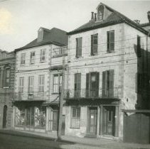
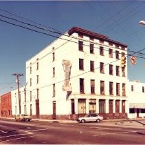
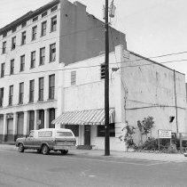
102 Broad Street and 104 Broad Street - 1980s
Twenty-four color photographs featuring 102 Broad Street and 104 Broad Street, various views and building details. A photo of the streetscape shows the mid-20th century building that was constructed at 100 Broad Street (later demolished). .
Record Type: Photo
-
102 Spring Street - 1990s?
Three color photographs of 102 Spring Street (and negatives), street (side) slevation), slightly different orientations.
Record Type: Photo
-
104 President Street - ca. 1980s
Color photograph a house identified as being on the southeast corner of President and Cannon Streets. Address is likely 104 President. Street (front) elevation. Apartment building in the background. "Behold God's Army" spray-painted on front. House is for sale by Fitzhenry Realty. Note on back indicates that the house collapsed and is gone now. There's no history on this building in HCF's Archives. What is known is that it was located on the s...
Record Type: Photo
-
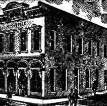
108 Meeting Street (N. Sottile Building) - ca. 1900
Digital image of a late-19th, early-20th century view of 108 Meeting Street as the N. Sottile building, possibly a restaurant. Engraving illustrated an advertisement in the 1902 City Directory.
Record Type: Photo
-
110-116 Meeting Street - ca. 1900
Reprint of a photograph of 108 Meeting, 110 Meeting, 112 Meeting, and 116 Meeting Streets, viewed from across the street (right to left). 108-112 Meeting were demolished ca. 1905. Only extant building is 114-116 Meeting (Old Lower Fire Station Building). Original photograph from the Charleston Museum Archives, photo MK5875.
Record Type: Photo
-
1-11 Ashley Boulevard - 2016, 2018
Three groupings of color digital photographs of the apartment building that was located at 1-11 Ashley Boulevard, demolished in 2019. Group A: Thirty photographs of various views of the exterior of the apartment building. Also includes details. Taken April 2016. Group B: Ten photographs of various views of the interior of the apartment building. Taken May 2016. Group C: Eight photographs showing various views of the dismantling of the bu...
Record Type: Photo
-
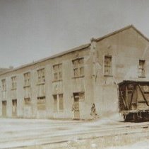
1-11 Vendue Range / North Atlantic Wharf Building / Union Pier - 1924-1925
Three photographs (scans of originals): a: View of the commercial buildings that had been located at 1-11 Vendue Range, southeast elevation, ca. 1924. Railroad car in foreground. b: View of a building on North Atlantic Wharf located by the railroad tracks. Identified as The E.S.T. Co. Offices on the 1902 Sanborn Map. Now the site of the City Gallery. Dated June 4, 1924. c: Aerial view of Union Pier buildings, looking east, showing two U...
Record Type: Photo
-
112-116 Spring Street and 224 Rutledge Avenue - 1930
B&W photograph (scan) of the view west on Spring Street from the corner of Rutledge Avenue, showing the edge of the Spring Street elevation of 224 Rutledge Avenue and 112 Spring Street, 114 Spring Street, and 116 Spring Street (R to L), street (front) elevations. Photo is captioned: "North side of Spring east of Rutledge Ave. Photo by St. J. Melcher, April 26, 1930." Original photograph from the Mayor Thomas Stoney Papers at the SC Historical...
Record Type: Photo
-
112 North Market Street and 190-200 Meeting Street - ca. 1982
Two color photographs of 112 North Market Street (Townsend, Arnold-Hornik Building/Planter's Inn) taken prior to the 1982 rehabilitation: a: Corner view of the building showing the south (front) and west elevations, including the small adjacent two-story building, and the street corner of Meeting and North Market Streets. Also shows Meeting Street buildings 190-194 Meeting Street, 196 Meeting Street, and 200 Meeting Street (Heart of Charleston...
Record Type: Photo
-
112 North Market Street and 190-200 Meeting Street - ca. 1982
Two B&W photographs of 112 North Market Street (Townsend, Arnold-Hornik Building/Planter's Inn) taken prior to the 1982 rehabilitation. Both show the south (front) elevation and the adjacent two-story building and parking lot at slightly different orientations. Photo B not scanned.
Record Type: Photo
-
114 Church Street - ca. 1920
Scan of photograph of 114 Church Street, corner view showing the weat (front) and north elevations. A small portion of the People's Building can be seen in the background. The house was demolished before the early 1920s when the Citizens and Southern Bank Building was constructed. Description on back: "Church Street North of Broad."
Record Type: Photo
-
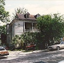
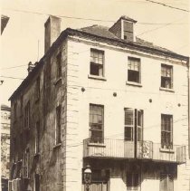
116 Rutledge Avenue - 1967
Two photographs (scans) of 116 Rutledge Avenue: a: West (front) elevation, showing the piazzas. View of the house is partially obstructed by trees. b: Corner view looking up at the piazzas on the upper story of the house (northwest corner). View of the lower story is obstructed by trees. Portion of an iron gate in foreground. The address appears in a list of "new buildings" in 1895 ("two-story wood dwelling") but not on the 1902 Sanborn ...
Record Type: Photo