Creator Record
Metadata
Creator/Author/Photographer |
Unattributed |
Related Records
-
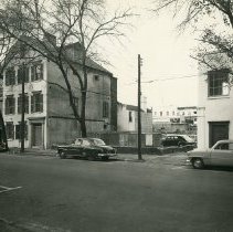
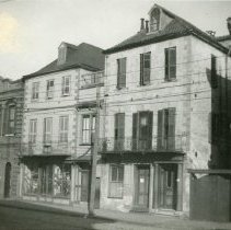
100-102 Broad Street - mid- to late-1950s
B&W photograph of Broad Street from 98 to 104, featuring the lot where Dr. Alexander Garden's house stood at 100 Broad Street and Dr. Henry Frost's house (102 Broad Street). Also in view are the enclosed piazza of 98 Broad Street (right) and a portion of the southeast corner of 104 Broad Street. Cars are parked on the street.
Record Type: Photo
-
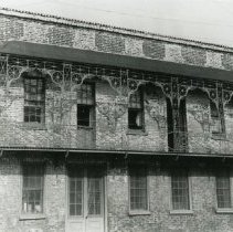
102-104 Church Street - 1970s?
Four B&W photographs of 102 Church Street: a: Southwest corner of the building and the street corner (Church and Elliott Streets). Also in view is 104 Church Street (left). b: Southwest corner of the building, featuring the south elevation. c: Street (west) elevation. Signage for "A Store of Quality Food - Miller's" affixed to building. d: North elevation. Driveway in foreground.
Record Type: Photo
-
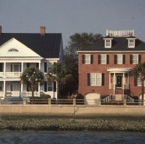
102 and 104 Murray Boulevard - 1985
Kodachrome slide featuring a view of 102 Murray Boulevard and 104 Murray Boulevard, taken from across the street, showing the south (front) elevations. Dated February 8, 1985.
Record Type: Photo
-
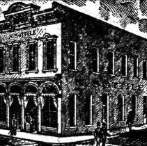
108 Meeting Street (N. Sottile Building) - ca. 1900
Digital image of a late-19th, early-20th century view of 108 Meeting Street as the N. Sottile building, possibly a restaurant. Engraving illustrated an advertisement in the 1902 City Directory.
Record Type: Photo
-
10 Coming Street (St. Michael's Glebe Tenement) - late-19th c.
Reprint of a photograph of the St. Michael's Glebe Tenement (10 Coming Street), front elevation and showing the southwest corner of the building, showing the original configuration of the house before its mid-20th century alterations. A child leans against the doorway while a toddler makes its way up the front steps, can a wagon is parked in front of the building. The original is a Charleston Museum photograph.
Record Type: Photo
-
10 Exchange Street - early 20th c.?
Reprint of a photograph of 10 Exchange Street showing the east elevation (Prioleau Street) with its cast-iron balcony. Original photo at The Charleston Museum Archives.
Record Type: Photo
-
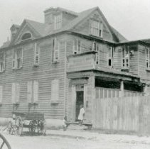
10 Sutherland Avenue - 1943, 1950s
Fifteen photographs (scans) of 10, 12, and 14 Sutherland Avenue: Photo 1: View of 10 Sutherland Avenue (center) and 8 Sutherland Avenue (barely visible in background), front elevation, corner view. Boy sits on curb in front of neighboring house. Dated 1943. Photo 2: View of 10 Sutherland Avenue (left) and 8 Sutherland Avenue (partially visible at right), front elevation, corner view. Boy stands with dog on lawn. Dated 1950. Photo 3: View...
Record Type: Photo
-
110-116 Meeting Street - ca. 1900
Reprint of a photograph of 108 Meeting, 110 Meeting, 112 Meeting, and 116 Meeting Streets, viewed from across the street (right to left). 108-112 Meeting were demolished ca. 1905. Only extant building is 114-116 Meeting (Old Lower Fire Station Building). Original photograph from the Charleston Museum Archives, photo MK5875.
Record Type: Photo
-
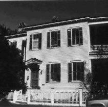
110 Ahley Avenue (Thayer-Lynah House) - 1996
B&W photograph of 110 Ahley Avenue (Thayer-Lynah House), street elevation.
Record Type: Photo
-
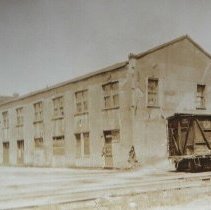
1-11 Vendue Range / North Atlantic Wharf Building / Union Pier - 1924-1925
Three photographs (scans of originals): a: View of the commercial buildings that had been located at 1-11 Vendue Range, southeast elevation, ca. 1924. Railroad car in foreground. b: View of a building on North Atlantic Wharf located by the railroad tracks. Identified as The E.S.T. Co. Offices on the 1902 Sanborn Map. Now the site of the City Gallery. Dated June 4, 1924. c: Aerial view of Union Pier buildings, looking east, showing two U...
Record Type: Photo
-
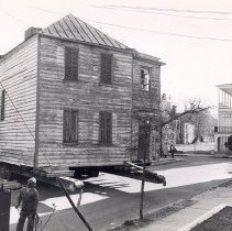
114 Anson Street Beinig Moved to 61 Laurens Street - ca. 1960s
Four B&W photographs showing originally located at 114 Anson Street being moved to 61 Laurens Street. Photo A captioned on back: "James Mackie House being moved to its present location." Photo C captioned on back: "James Mackie House and another 18th century house moved to this corner. Both restored on exterior by Historic Charleston Foundation and sold as part of the Ansonborough Rehabilitation Project."
Record Type: Photo
-
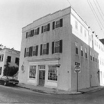
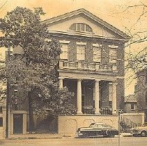
114 Broad Street (Col. Thomas Pinckney House) - 1950s
B&W photograph of 114 Broad Street (Col. Thomas Pinckney House). Two cars parked on street in front. Likely by Louis Schwartz.
Record Type: Photo
-
116 Queen Street - 1966, ca. 1980
Five photographs (scans) showing 116 Queen Street: a: Front (south) elevation. Photo dated May 1966. b: View of the doorway, ca. 1980. c: Man standing in the doorway, ca. 1980. d: View of the house from across the street, showing the south and west elevations, ca. 1980 e: Family members posing in front of the doorway, ca. 1980. (Not shown in online catalog.)
Record Type: Photo
-
119-121 Meeting Street [now 177 Meeting] - 1886
B&W reprint of a photograph of a four-story building identified as "East Storage" at what was 119 Meeting Street, taken sometime after the 1886 Earthquake. "A. Kennedy" painted over the entry what would have been 121 Meeting. Current address is 177-179 Meeting Street. A portion of the drug store to the north at what would have been 181 Meeting also in view at right; now lost.
Record Type: Photo
![177 Meeting [f/k/a 119 Meeting], 1886](https://s3.amazonaws.com/pastperfectonline/images/museum_138/037/thumbs/meeting1776.jpg)
-
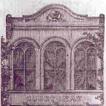
11 Broad Street (Courtenay Book Store) - 1865 (date of original)
Photographic reprint of an engraving of 11 Broad Street (Courtenay Building). Illustrates advertisement for the book store. Reproduced from The Courier, 1856. Address given as 9 Broad Street in the advertisement.
Record Type: Photo