Photos
4078 results found sorted by relevance. Records searched: 4078
-
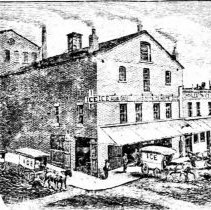
72 North Market Street (Charleston Ice Works) - ca. 1892
Digital image of a late-19th century view of the Charleston Ice Works building, identified as 72 North Market Street. Engraving illustrated an advertisement in the 1892 City Directory.
Record Type: Photo
-
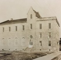
Jerusalem Baptist Church (26 Maverick Street) - ca. 1920s?
B&W photograph (scan) of Jerusalem Baptist Church (26 Maverick Street), street (front) elevation. (Possibly also known as Westminster Church.) Original photograph from the Mayor Thomas Stoney Papers at the SC Historical Society. Contact SCHS for permission to publish.
Record Type: Photo
-
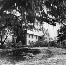
Medway Plantation - Undated
B&W photograph of Medway Plantation, view from across the grounds.
Record Type: Photo
-
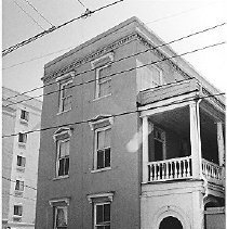
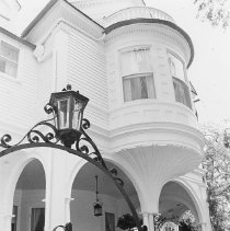
Carrington-Carr House (2 Meeting Street) - ca. 1996
Three B&W photographs of the Carrington-Carr House (2 meeting Street) featuring the bay window and arched piazza. Iron gate in foreground.
Record Type: Photo
-
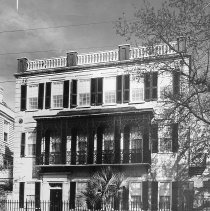
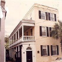
Thomas Tucker House (8 Meeting Street) - 1970
B&W photograph of the Thomas Tucker House (8 Meeting Street), west (front) elevation with cast iron balcony. Captioned: "Home of Mr. and Mrs. David Maybank, Jr. A most distinguished Regency residence faced onto a truncated 'single house' of an early Adam type."
Record Type: Photo
-
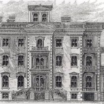
Residence of Geo. W. Williams, Esq. (16 Meeting Street) - 1875
Photographic print of engraving of the residence of George W. Williams, 16 Meeting Street (Williams Mansion f/k/a Calhoun Mansion), from the publication Guide to Charleston Illustrated, by Arthur Mazyck.
Record Type: Photo
-
31 Society Street (John W. Robinson Tenement) - ca. 1960
B&W photograph of 33 Society Street (John W. Robinson Tenement), street (front) elevation. ARP [Ansonborough Rehabilitation Project] handwritten on verso of photo.
Record Type: Photo
-
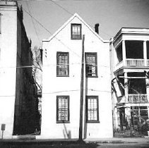
38 Society Street - ca. 1960
Two B&W photographs of 38 Society Street, street (front) elevation. a: Shows portions of 34 Society Street and 40 Society Street. ARP [Ansonborough Rehabilitation Project] written on back. b: Slight corner view. Shows portion of 40 Society Street.
Record Type: Photo
-
40 Society Street (Juliana Dupre House) - ca. 1980s?
Seventeen color photographs of 40 Society Street, various exterior elevations.
Record Type: Photo
-
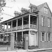
42 Society Street (Juliana Dupre Tenement) - ca. 1961
B&W photograph of 42 Society Street (Juliana Dupre Tenement), street (front) elevation, corner view of building showing piazzas. For sale sign on gate post; house is for sale by HCF through the Ansonborough Rehabilitation Project. Gate is closed and house has white shutters. 5x7 print also in sleeve.
Record Type: Photo
-
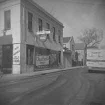
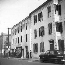
Kestler's Market/Susan Robinson Tenements (48 Society Street) - ca. 1960s
B&W photograph of "Kestler's Market" at 48 Society Street, street elevation, before neighborhood rehabilitation. Coca Cola sign underneath store sign. Advertisement for Claussen's Bread on front of building; Claussen's Bread truck on street. Sign for "Fresh Vegetables" on side of building. "ARP" written on back of photo. Also known as 61 Anson Street.
Record Type: Photo
-
49 Society Street and 51 Society Street - ca. 1960s
B&W photograph of 49 Society Street and 51 Society Street, street (front) elevation. Corner of Society Street and Anson Street. ARP [Ansonborough Rehabilitation Project] written on back.
Record Type: Photo
-
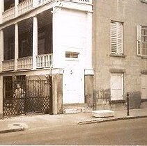
52 Society Street (James M. Stocker House) [and 54 Society Street] - 1960s
Two B&W photographs of 52 Society Street (James M. Stocker House): a: Street (front) elevation, showing piazza; partial view of house (ground and first story). Gate is closed (woman standing behind the gate) and house has white shutters. Dated Feb. 7, 1965. Photo measures ~3"x2.5". b: Street (front) elevation, corner view of house. Appears to be a wood gate, not the ironwork gate in other, later photos. Neighboring house also in view (...
Record Type: Photo
-
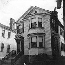
19 State Street (Frederick Wolfe House) - ca. 1996
B&W photograph of 19 State Street (Frederick Wolfe House), street (front) elevation. Three photographs in sleeve, different orientations. Formerly located at 21 State Street.
Record Type: Photo
-
75 Society Street (Eckhardt-Patrick House) - ca. 1996
B&W photograph of 75 Society Street (Eckhardt-Patrick House), street (front) elevation, corner view. Two copies of photo in sleeve.
Record Type: Photo