Search Term Record
Metadata
Search Terms |
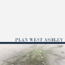
West Ashley |
Related Records
-
1040 Fifth Avenue [1040 5th Avenue], the King House - 2002
Eight color photographs (negatives) of the King House [1040 Fifth Avenue] in Maryville. a-d: Front of house, various views. e: Grounds. f-g: Side of house (pool side). h: Oak avenue. Photos C and F have been printed.
Record Type: Photo
-
-
-
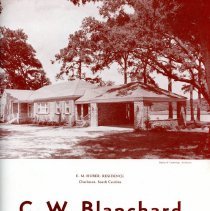
Brochure - C.W. Blanchard, Contractor and Builder
Promotional brochure for C.W. Blanchard,* Contractor and Builder, featuring photographs of some of the houses and buildings that the company constructed, designed, and/or renovated. Page 1: "E.M. Huber Residence, Charleston, South Carolina, Halsey & Cummings, Architects" [24 Country Club Drive] Page 2: Two photographs: "The Citizens & Southern National Bank, West Ashley, Charleston, South Carolina, Lane-Austin-Rogers, Architects" [17 Avonda...
Record Type: Archive
-
Collection - Miscellaneous Property Files
Miscellaneous information divided into categories and covering properties not identified by a specific street address or that are outside the historic district. Files may contain newspaper articles, narrative histories, maps, reports, and photocopies of images. Series 1: Neighborhoods/Areas Adams Run; The Battery; Cainhoy; Charleston Neck; Colonial Lake; Daniel Island; Downtown Neighborhoods (general); Dunes West (Brickyard Plantation); E...
Record Type: Archive
-
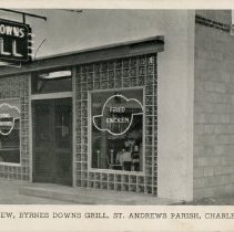
Exterior View, Byrnes Downs Grill, St. Andrews Parish, Charleston, S.C. - ca. 1950
Photographic postcard of Byrnes Downs Grill. On verso: "Byrnes Downs, named in honor of former Secretary of State James F. Byrnes, a native South Carolinian. Byrnes Down Grill located on highway 17 at intersection highway 61, 1 mile West of Ashley River Bridge, Charleston, South Carolina. Specializing in southern fried chicken, fried chicken, western steaks and fresh Charleston seafoods." Address was 173-B Savannah Highway. Published by...
Record Type: Photo
-
Map - City of Charleston
Map of Peninsula, West Ashley and James Island including City of Charleston Boundaries. Created by Owen Ayres & Associates. Inc.
Record Type: Archive
-
Map - Official Zoning Map-West Ashley
4 official zoning maps prepared by the Dept. of Planning and Urban Development. Includes amendments signed by the Clerk of Council and Zoning Administrator. 1. Grid 2 2. Grid 3 3. Grid 6C 4. Grid 7
Record Type: Archive
-
Map - Wappoo Realty Company, General Plan for "The Crescent"
Color plan illustrating the layout of the lots in the area known as "The Crescent." Created by the Olmsted Brothers for Wappoo Realty Company, September 1926. Includes lot numbers.
Record Type: Archive
-
Map - Zoning Maps: West Ashley and Charleston Peninsula
Map of West Ashley and map of the Charleston peninsula indicating zone number, district, classifications, and the Old and Historic District. Full-size pages from The Evening Post, dated May 5, 1966, appearing under a notice for a Zoning Hearing, Proposed New City Zoning Ordinance. Maps prepared by Candeub, Fleissig & Associates, Planning Consultants (Atlanta), under contract with the City of Charleston.
Record Type: Archive
-
Oral History - An Interview with Emily Ravenel Farrow [DVD]
Farrow, Emily Ravenel, b. 1915
Record Type: Library
-
![Interview with Diane Hamilton [DVD]](https://s3.amazonaws.com/pastperfectonline/images/museum_138/033/thumbs/2018002028.jpg)
-
Properties in the Right-of-Way - 1960s
B&W photographs of buildings and other properties located in Charleston County that were destroyed, relocated, or otherwise modified because they were in the right-of-way of where roads were being constructed or widened. Building and dwelling types include houses, apartment buildings, freedman's cottages, mobile homes, commercial and industrial buildings, churches, schools, gas stations, restaurants, grocery stores and corner markets, garages, sh...
Record Type: Photo
-
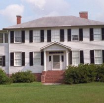
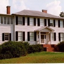
Property File - 1040 Fifth Avenue [1040 5th Avenue] (Maryville) (King House)
Constructed early 1920s. Henry F. Walker, architect. Ernest W. King began planting vegetables in St. Andrews Parish and established himself as a leading truck farmer. He owned a large tract in the area that is now Maryville, on which he built this house in the early 1920s. The King House is a two-story frame building with a hipped roof, center entry with transom and sidelights under a gabled portico, and a raised English basement. The influence o...
Record Type: Archive
-