Search Term Record
Metadata
Search Terms |
Liberty Street |
Related Records
-
Map - Map of Neighborhood of The College of Charleston
Title of drawing: Map of Neighborhood of The College of Charleston Date of drawing: 5/26/1968, 1/14/1970* Name of creator(s): S.T. Map of College of Charleston and neighboring buildings, indicating architectural significance as established in This is Charleston. also indicates properties owned by College of Charleston. Encompasses area bounded by Calhoun Street, Coming Street, and Wentworth Street. (Eastern boundary not indicated.) "Compi...
Record Type: Archive
-
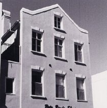
Mordecai Cohen Building (297 King Street) - ca. 1996
B&W photograph of the Mordecai Cohen Building (297 King Street, east (front) elevation, located at the southwest corner of King and Liberty Streets. Occupied by Pete Banis Shoes.
Record Type: Photo
-
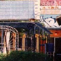
Property File - 5 Liberty Street (Arcade Theater)
Constructed ca. 1948 in the Art Moderne style by Augustus Constantine. Demolished ca 2003. File contains building history from scmovietheaters.com; newspaper articles about preservationists efforts to save the building and about the demolition. Digital image only, from www.scmovietheaters.com/chas_arc.html.
Record Type: Archive
-
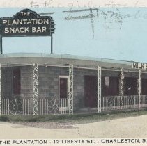
The Plantation Snack Bar - 12 Liberty St. - Charleston, S.C. - ca. 1954
Postcard featuring The Plantation Snack Bar at 12 Liberty Street. Sign for "Milk Shakes" on the eave at the front of the building. Back of postcard is postmarked February 15, 1954, and has a two-cent postage stamp. Captioned: "Modern up to date drive in, in the heart of the City. Catering to those who delight in clean, prompt and courteous service. Noted for their famous Plantation milk shakes and sandwiches." Published by Nation Wide Post ...
Record Type: Photo