Search Term Record
Metadata
Search Terms |
Elizabeth Street |
Related Records
-
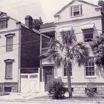
10-12 Elizabeth Street (John Carburry House and Neighbors) - ca. 1996
B&W photograph of 10-12 Elizabeth Street, west (front) elevation. 10 Elizabeth at right; 12 Elizabeth at left.Three photos in sleeve, taken at slightly different orientations.
Record Type: Photo
-
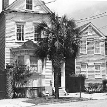
12 Elizabeth Street (John Carburry House) - 1980
Two color Kodachrome slides of 12 Elizabeth Street, west (front) elevation. Slide B date-stamped May '80.
Record Type: Photo
-
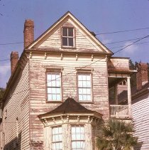
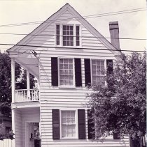
14 Elizabeth Street (Sarah Rutledge Hort House) - ca. 1996
Four B&W photographs of 14 Elizabeth Street (Sarah Rutledge Hort House), west (front) elevation, taken at slightly different orientations. Elizabeth Street/Henrietta Street street sign in foreground of photo #1.
Record Type: Photo
-
14 Elizabeth Street (Sarah Rutledge Hort House) Photographic Documentation for Rehabilitation - ca. 1997-1999
Fifty-one color photographs documenting the conditions of 14 Elizabeth Street. Interior and exterior views (all elevations). Includes photos of the outbuilding. May be a combination of before and after photographs. Photographs probably taken in support of a Part I and/or Part II certification application.
Record Type: Photo
-
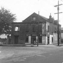
19 Elizabeth Street (Henry Bulwinkle Grocery) - ca. 1960s
B&W photograph of 19 Elizabeth Street (Henry Bulwinkle Grocery a/k/a Smith's Grocery). East (front) elevation with view of corner of Elizabeth Street and Charlotte Street. "Smith's Grocery - Meats - Fresh Fruit" painted on building. 8x10 enlargement also in sleeve.
Record Type: Photo
-
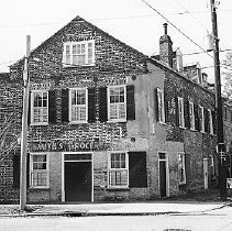
19 Elizabeth Street (Henry Bulwinkle Grocery) - ca. 1996
Three B&W photographs of 19 Elizabeth Street (Henry Bulwinkle Grocery), east (front) elevation, taken at slightly different orientations, including the view shown here (corner of Elizabeth Street and Charlotte Street), with the rear of the Mendel Rivers Building visible in the background.
Record Type: Photo
-
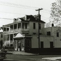
1 Henrietta Street - ca. 1998
Color photograph of 1 Henrietta Street and the corner of Henrietta and Elizabeth Street. Street elevation, northeast corner of the building. "For Lease" sign on east elevation.
Record Type: Photo
-
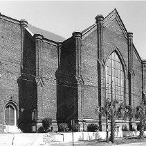
22 Elizabeth Street (New Tabernacle Fourth Baptist Church) - Undated
22 Elizabeth Street (New Tabernacle Fourth Baptist Church, formerly known as St. Luke's Episcopal Church), south (Charlotte Street) elevation.
Record Type: Photo
-
2 and 4 John Street - ca. 1980
B&W photograph of 2 John Street and 4 John Street (Gibbes House), corner view of the buildings showing the south (front) and east elevations and a view of the street corner (John and Elizabeth Streets). Also shows the corner of nearby Chapel and Elizabeth Streets. Car parked on street in front.
Record Type: Photo
-
30 Mary Street (Mary Street Sweet Shop) - 1977
B&W photograph of 30 Mary Street, south (front) elevation. Also shows where Elizabeth Street intersects Mary Street. Sign for "Mary St. Sweet Shop" posted over the store entrance. View of 32 Mary Street at left.
Record Type: Photo
-
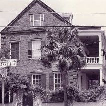
31 Elizabeth Street - ca. 1996
Two B&W photographs of 31 Elizabeth Street: a: East (front) elevation. b: View of the house from the corner of Elizabeth Street and John Street, showing the northeast corner of the house.
Record Type: Photo
-
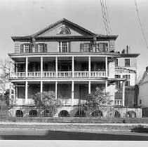
48 Elizabeth Street (Aiken-Rhett House) - 1977-1979
Fifty-nine photographs of 48 Elizabeth Street (Aiken-Rhett House), interior and exterior shots. Photographer's description/note(s): 1) SW sides, showing entire W side of complex (R to L: house, gallery, carriage house and stable, courtyard wall) 2) S side (John Robinson ca. 1817), remodeled ca. 1835 and 1858 by William Aiken) [pictured here] 3) SE sides, including detail of brick wall pier terminal 4) N side carriage house and stable on...
Record Type: Photo
-
4 Elizabeth Street - ca. 1996
B&W photograph of 13 Elizabeth Street, east (front) elevation. Three photos in sleeve, taken at slightly different orientations.
Record Type: Photo
-
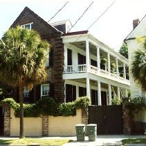
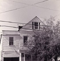
4 Elizabeth Street (Dereef House) - ca. 1996
B&W photograph of 4 Elizabeth Street (Dereef House), street (front) elevation. Two copies of photo in sleeve. Description of house from The Buildings of Charleston: Constructed ca. 1870. The Dereefs, a wealthy free African American family with substantial holdings before the Civil War,built this 2-story wood Charleston single house on a corner adjacent to an early lane now called Harlem Court. This alley, largely peopled with African American ...
Record Type: Photo
-
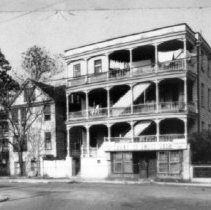
51-53 Elizabeth Street (John P. Daly Houses) - ca. 1996
B&W photograph of 51-53 Elizabeth Street (John P. Daly Houses), east (front) elevation. Two copies of photo in sleeve.
Record Type: Photo