


Search Term Record
Metadata
Search Terms |
Charleston Neck |
Related Records
-
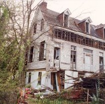
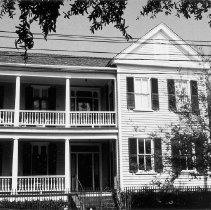
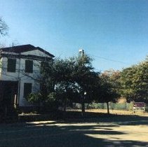
900 Rutledge Avenue - 1995
Five color photographs of 900 Rutledge Avenue: south and east elevations; east elevation; south elevation; north elevation. Taken March 17, 1995. House is in severe disrepair. Handwritten note on photo envelope: Noisette Farmhouse.
Record Type: Photo
-
Aerial View of Charleston Peninsula, ca. 1957 - ca. 1957
Aerial view of Charleston, looking east across the peninsula. Landmarks include the Citadel campus, Stoney Field, the Ashley River Bridge as it ends in the vicinity of Cannon and Spring Streets, the West Side, and the industrial area at the Charleston Neck. Written on back: No.: UJ-62-293 Unit: UJ-62 Made for: P.I. Subject: Aerial of Charleston, S.C.
Record Type: Photo
-
Aerial View of Charleston Peninsula, ca. 1957 - ca. 1957
Aerial view of Charleston, looking east across the peninsula. Landmarks include the West Ashley Bridge, the Citadel campus, Stoney Field, the Ashley River Bridge as it ends in the vicinity of Cannon and Spring Streets, the West Side, and the industrial area at the Charleston Neck. Written on back: No.: 2644-C Unit: UJ-62 Made for: P.I. Subject: Charleston, S.C.
Record Type: Photo
-
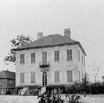
Belvidere Plantation - Early 20th c.
Belvidere Plantation, the ca. 1800 Charleston Neck seat of Col. Thomas Shubrick, demolished in 1925 by the Standard Oil company (BOC, p. 175). See property file under PLANTATIONS.003. for plantation history. Also known as Belvedere Plantation.
Record Type: Photo
-
Booklet - Between the Tracks: The Heritage of Charleston's East Side Community
Grimes, Kimberly M.
Record Type: Library
-
Collection - Miscellaneous Property Files
Miscellaneous information divided into categories and covering properties not identified by a specific street address or that are outside the historic district. Files may contain newspaper articles, narrative histories, maps, reports, and photocopies of images. Series 1: Neighborhoods/Areas Adams Run; The Battery; Cainhoy; Charleston Neck; Colonial Lake; Daniel Island; Downtown Neighborhoods (general); Dunes West (Brickyard Plantation); E...
Record Type: Archive
-
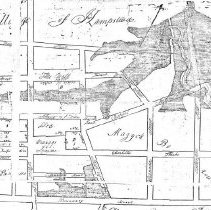
Plat - Plan of Wraggborough on Charleston Neck...
Title of drawing: Plan of Wraggborough on Charleston Neck... Date of plat: Dec. 18, 1805 Name of creator: Joseph R. Purcell Shows Village of Hampstead and Mazyckborough and the area bounded by Mary Street, King Street, Boundary Street, and the Cooper River. Recorded Feb. 15, 1806 From Book Q7, Page 413, RMC.
Record Type: Archive
-
Property File - 107 Brigade Street
File contains research report,"The Wiskey Arsenal" (Meghan Olson, 2016),containing historical research on the property bounded by Brigade Street, Morrison Drive, and North Romney Street. Includes Charleston Neck history and information about the Rumney Distillery, State Arsenal, N. Goldberg Company, and Charleston Steel and Metal Company. (PDF available on Media link.) (The distillery had been owned by Nathaniel Russell, Aaron Loocock, and Andrew...
Record Type: Archive
-
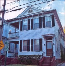
Property File - 22 Charlotte Street (Maria Smith House)
Built on a lot on lands subdivided by Alexander Mazyck. A T-shaped, 2-story wooden building, with closed gable end and double-tiered piazzas. File contains inspection report of Hurricane Hugo damage, including photos (Rosen & Associates, 1991); graduate student report (Sun Tianying, 2010) on the history of the house, which includes historical and chain-of-title research, maps, photos, and other supporting documentation.
Record Type: Archive
-
Property File - 26 Charlotte Street
Constructed some time between 1917 and 1930. Two-story single house on brick foundation. Thought to have hand American Revolution fortifications constructed on the site in the late 1770s. File graduate student report (Mariah Schwartz, 2010) on the history of the house, which includes historical and chain-of-title research, maps, photos, and other supporting documentation. No photos on file. Image in this record is from document in the Pr...
Record Type: Archive
-
Property File - 645 East Bay Street
Parcel of land consisting of two lots, located inside the boundaries of the historic Village of Hampstead. A three-story Charleston single house is on the lot, constructed in 1880. File contains graduate student report (John Evangelist, 2014) on the history of the property, which includes historical and chain-of-title research, maps, photos, and other supporting documentation.
Record Type: Archive
-
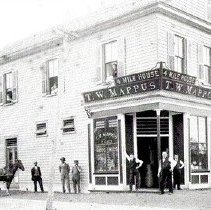
Property File - Four Mile House (Meeting Street Road)
There seem to be several houses or structures named Four Mile House, Five Mile House, Six Mile House, etc. It is uncertain whether or not the names pertain to the same house/structure or for different ones. The location is in the area near or on what is now known as Meeting Street Road. Needs further research. File contains Preservation Progress article about the Four Mile House associated with John and Lavinia Fisher (1967); research no...
Record Type: Archive
-
Property File - Lowndes Grove Plantation [266 St. Margaret Street]
Present house constructed ca. 1790, also known as Grove Plantation, F.W. Wagener Residence (Wagener Farm). The Grove Plantation was developed about the middle of the 18th century by John Gibbes. His plantation house with its large garden of exotic plants was destroyed during the Siege of Charleston by the British in 1780. It stood some distance to the southwest of the present house, which was built before 1790 by George Abbott Hall. The house was...
Record Type: Archive
![Lowndes Grove Plantation [266 St. Margaret Street]](https://s3.amazonaws.com/pastperfectonline/images/museum_138/013/thumbs/cat recs 2_oversize_walkwagener.jpg)
-
Report - Between the Tracks: Charleston's East Side During the Nineteenth Century
Rosengarten, Dale
Record Type: Library
-
Thesis - Constructing Free Identity: The Invention and Adaptation of the Charleston Freedman's Cottage
Wagoner, Page Marie
Record Type: Library