Search Term Record
Metadata
Search Terms |
Ansonborough Rehabilitation Project (ARP) |
Related Records
-
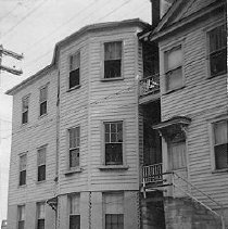
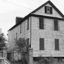
10 Wentworth Street (Charles W. Seignious House) - ca. 1960s
B&W photographs of 10 Wentworth Street (Charles W. Seignious House), street (front) elevation, corner view showing piazzas. Laundry hangs on second floor piazza. ARP [Ansonborough Rehabilitation Project] written on verso of photograph.
Record Type: Photo
-
114 Anson Street Before Relocation to 61 Laurens Street - ca. 1950s
B&W photograph of 114 Anson Street, street (front) elevation, corner view, before the house was moved to 61 Laurens Street to clear the property on which the Gaillard Municipal Auditorium was to be constructed. Car parked on street.
Record Type: Photo
-
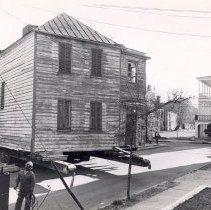
114 Anson Street Beinig Moved to 61 Laurens Street - ca. 1960s
Four B&W photographs showing originally located at 114 Anson Street being moved to 61 Laurens Street. Photo A captioned on back: "James Mackie House being moved to its present location." Photo C captioned on back: "James Mackie House and another 18th century house moved to this corner. Both restored on exterior by Historic Charleston Foundation and sold as part of the Ansonborough Rehabilitation Project."
Record Type: Photo
-
116 Anson Street (39 Laurens Street) - 1967
Two B&W photographs (scans) of 116 Anson Street prior to its move to 39 Laurens Street. Handwritten on back of both photos: "Owned by Historic Charleston Foundation." Photograph dated June 17, 1967. Likely taken by Earle Newton, President of the Historic St. Augustine Preservation Board.
Record Type: Photo
-
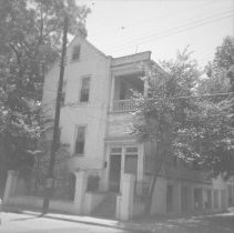
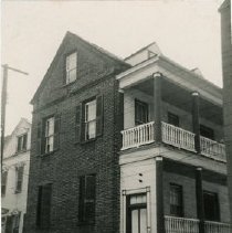
11 George Street (Mary Scott House) - 1960s
B&W photograph of the Maray Scott House (11 George Street), corner view, north (front) and west (piazzas) elevations, partially obscured by trees. ARP [Ansonborough Rehabilitation Project] handwritten on verso of photo. The address of the house at the time was 7 George Street.
Record Type: Photo
-
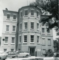
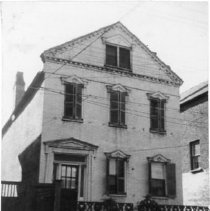
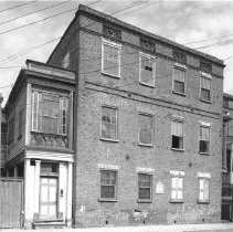
14 George Street (Middleton-Pinckney House) - ca. 1960
B&W photograph of 14 George Street (Middleton-Pinckney House), then the City Water Works offices. North (front) elevation. Cars parked in front of building. Captioned on back "14-18 George Street." "ARP" [Ansonborough Rehabilitation Project] written on back.
Record Type: Photo
-
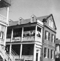
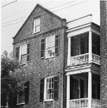
15 Wentworth Street (Christopher Myers House) - ca. 1970s
B&W photograph of 15 Wentworth Street (Christopher Myers House), street (front) elevation.
Record Type: Photo
-
18-20 Wentworth Street (Lopez-Moise Tenements) - ca. 1960s
B&W photograph of 18-20 Wentworth Street (Lopez-Moise Tenements), street (front) elevation, before rehabilitation. 20 Wentworth Street is at left. Burbage handwritten on verso.
Record Type: Photo

-
18-20 Wentworth Street (Lopez-Moise Tenements) - ca. 1960s
B&W photograph of 18-20 Wentworth Street (Lopez-Moise Tenements), street (front) elevation, before rehabilitation. 18 Wentworth Street is at right. Burbage handwritten on verso.
Record Type: Photo
-
19 Wentworth Street (William Lebby House) 19 Wentworth Street (William Lebby House) - 1960s
Two B&W photographs of 19 Wentworth Street (William Lebby House): a: Street (front) elevation, corner view. ARP [Ansonborough Rehabilitation Project] written on verso of photograph. b: Street (front) elevation. Polaroid dated Feb. 7, 1965.
Record Type: Photo
-
21 Wentworth Street - 1960s
B&W photograph of 21 Wentworth Street, street (front) elevation, view of piazzas. ARP [Ansonborough Rehabilitation Project] written on verso.
Record Type: Photo
-
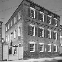
22-24 Wentworth Street (Francis Q. McHugh Tenements) After Rehabilitation - ca. 1968
B&W photograph of 22-24 Wentworth Street (Francis Q. McHugh Tenements), street (front) elevation, after rehabilitation. Portion of 20 Wentworth Street at right. Two copies of photo in sleeve.
Record Type: Photo
-
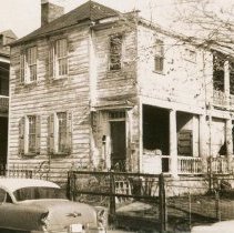
22-24 Wentworth Street (Francis Q. McHugh Tenements) Before Rehabilitation - ca. 1966
B&W photograph of 22-24 Wentworth Street (Francis Q. McHugh Tenements), street (front) elevation, before rehabilitation. Portion of 20 Wentworth Street at right. Two copies of photo in sleeve.
Record Type: Photo
-
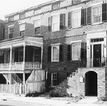
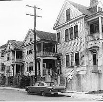
23-29 Society Street (23 Society Street, 25 Society Street, 27 Society Street, 29 Society Street - ca. 1960
B&W photograph of 23-29 Society Street, street (front) elevation, showing 23 Society Street, 25 Society Street, 27 Society Street, and 29 Society Street. For Rent sign posted on 29 Society Street. 23, 25, and 27 Society Street are now gone.
Record Type: Photo
-
23 Society Street - ca. 1960
B&W photograph of 23 Society Street, street (front) elevation, showing a portion of 25 Society. ARP [Ansonborough Rehabilitation Project] handwritten on verso of photo.
Record Type: Photo