Related Records
-
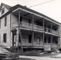
116 Anson Street (39 Laurens Street) - 1967
Two B&W photographs (scans) of 116 Anson Street prior to its move to 39 Laurens Street. Handwritten on back of both photos: "Owned by Historic Charleston Foundation." Photograph dated June 17, 1967. Likely taken by Earle Newton, President of the Historic St. Augustine Preservation Board.
Record Type: Photo
-
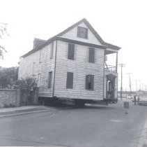
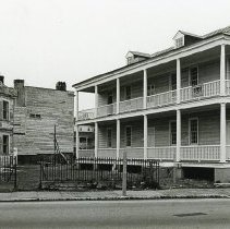
116 Anson Street Being Moved to 39 Laurens Street - ca. 1960s
Two B&W photographs of the house originally located at 116 Anson Street being moved to the southwest corner of Laurens and East Bay Streets, which would become the address 39 Laurens Street.
Record Type: Photo
-
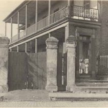
309 East Bay Street - ca. 1910
Photograph (scan) of a portion of a building identified as 309 East Bay Street, front (east) elevation, showing the entry steps, gate, and piazzas. Small child stands in doorway.
Record Type: Photo
-
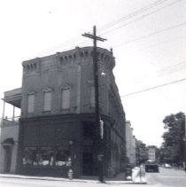
309 East Bay Street [39 Laurens Street] - ca. 1960s
B&W photograph of 309 East Bay Street, which was located at the southwest corner of East Bay and Laurens Streets, before demolition. The house originally located at 116 Anson Street was moved to this site, with the address of 39 Laurens Street. "ARP" [Ansonborough Rehabilitation Project] handwritten on back of photo.
Record Type: Photo
![309 East Bay Street [39 Laurens Street]](https://s3.amazonaws.com/pastperfectonline/images/museum_138/035/thumbs/laurens0399.jpg)
-
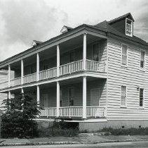
39 and 41 Laurens Street - ca. 1975
B&W photograph of 39 Laurens Street after restoration, corner view showing the east (East Bay Street) and south (piazzas) elevations. Set back and to the left is the east elevation of 41 Laurens Street.
Record Type: Photo
-
39 and 41 Laurens Street - ca. 1995
B&W photograph of 39 Laurens Street (south elevation) (R) and 41 Laurens Street (east elevation) (L).
Record Type: Photo
-
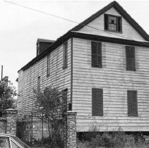
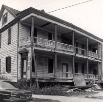
39 Laurens Street - ca. 1966
B&W photograph of 39 Laurens Street after its move from 116 Anson Street.
Record Type: Photo
-
39 Laurens Street - ca. 1995
B&W photograph of 39 Laurens Street, corner view showing the east (East Bay Street) and south (piazzas) elevations.
Record Type: Photo
-
Drawing, Architectural - Proposed Rehabilitation [of 39 Laurens Street] for Historic Charleston Foundation
Title of drawing: Proposed Rehabilitation [of 39 Laurens Street] for Historic Charleston Foundation Date of drawing: 7/1973 Name of creator(s): Russell Wright East Elevation, South Elevation. "For estimates only." Drawing contains handwritten notes and measurements. Note: These proposed plans were executed.
Record Type: Archive

-
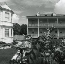
Plan, Landscape (Garden) - A Master Development Plan for Thomas P. Ford, 39 Laurens Street
Title of drawing: A Master Development Plan for Thomas P. Ford, 39 Laurens Street Date of drawing: 8/14/1979, Revised:8/15-8/17/1979 Name of creator(s): Robert C. Chesnut, Landscape Architect, ASLA Site Plan, Column Detail, Street Elevation, Brick Paving Detail, Lattice Detail. Drawing is presumably part of a set of landscaping plans (based on page numbering in title block). Drawings labeled as: Construction. Commission: 79524
Record Type: Archive
-
Plat - 39 Laurens Street, 41 Laurens Street, 43 Laurens Street
Title of drawing: 39 Laurens Street, 41 Laurens Street, 43 Laurens Street Date of drawing: 1/23/1973 Name of creator(s): Not Indicated Plat. Drawing title: Plat of Numbers 39, 41 & 43 Laurens Street. Drawing contains handwritten notes.
Record Type: Archive
-
Plat - Plat of Nos. 39 Laurens Street, 41 Laurens Street, and 43 Laurens Street
Title of drawing: Plat of Nos. 39 Laurens Street, 41 Laurens Street, and 43 Laurens Street Date of drawing: 6/21/1976 Name of creator(s): George A.Z. Johnson, Jr., Inc. Plat showing "The Readjustment of Property Lines of Lot Nos. 305, 307 & 309 East Bay and 43 Laurens St." Plat approved by Asst. City Engineer. Includes blueprint and reduced-sized photocopy annotated to reflect house footprints.
Record Type: Archive
-
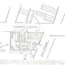
Plat - Proposed Redesign of the Corner of Laurens and Bay Streets [39 Laurens Street, 41 Laurens Street, 43 Laurens Street]
Title of drawing: Proposed Redesign of the Corner of Laurens and Bay Streets [39 Laurens Street, 41 Laurens Street, 43 Laurens Street] Date of drawing: 12/1972 Name of creator(s): Russell Wright Plat showing the "Proposed Redesign of the Corner of Laurens and Bay Streets." Drawing done for Historic Charleston Foundation. Annotated to indicate the relocation of the building moved to 39 Laurens. Note that the parking area shown in ...
Record Type: Archive
-
Property File - 309 East Bay Street
Two-story masonry store and dwelling constructed ca. 1905. The ground floor operated as a grocery for at least six decades until it was demolished at the request of Historic Charleston Foundation so that the 18th century house at 116 Anson Street could be moved to the site. After it was relocated, the house was given the address 39 Laurens Street. No additional building history on file. Needs further research. File contains occupancy histo...
Record Type: Archive
-
Property File - 39 Laurens Street
Late 18th century building with fine interior woodwork. Initially moved from 116 Anson Street to then 42 Laurens while the lots at 305-309 East Bay Street were cleared, then to its current location. HCF restored the exterior in the early 1970s. (Site was originally known as 309 East Bay Street.) Three files contain documentation of the covenant on the property; correspondence and other documentation related to the covenant, including right-of-...
Record Type: Archive