Creator Record
Metadata
Creator/Author/Photographer |
Cook, George LaGrange |
Related Records
-
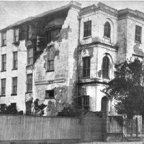
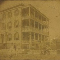
26 Meeting Street (William Mason Smith House) After 1886 Earthquake - 1886
Reprint of post-1886 Earthquake photograph of the William Mason Smith House (26 Meeting Street, showing damage done to the north and west elevations. Original photograph at Gibbes Museum of Art
Record Type: Photo
-
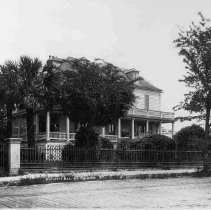
274 Calhoun Street (Daniel Cannon House) - 1880s
B&W photograph of 274 Calhoun Street (Daniel Cannon House), street (front) elevation. Title written on photo: "Rutledge Residence on Calhoun Street."
Record Type: Photo
-
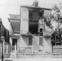
39 Meeting Street After the 1886 Earthquake - 1886
Reprint of a photograph of 39 Meeting Street) showing the damage to the east (front) elevation after the 1886 Earthquake.
Record Type: Photo
-
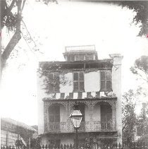
43 Bull Street - 1886
B&W photograph of 43 Bull Street, street elevation, presumably taken shortly after the 1886 Earthquake, showing roof damage. Three children on sidewalk in front of gate.
Record Type: Photo
-
4 Gadsden Street After Restoration - 1886
Photograph (scan) of 4 Gadsden Street after the house was restored by George Egan, the builder and contractor who purchased the house in 1886. Egan appears on horseback in front of the house. Photographer's stamp on back: "Geo. L. Cook, Shotographer, 265 King Street, Charleston, S.C" [George L. Cook].
Record Type: Photo
-
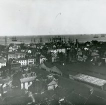
Charleston Harbor (Aerial View) - 1880s
B&W photograph showing an aerial view of Charleston buildings, wharves, and industrial sites. Ships in the Charleston Harbor in the background. 90-92-94 Church Street can be seen close to the center of the photograph.
Record Type: Photo
-
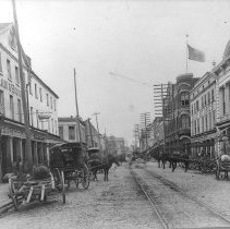
Looking South on East Bay Street from 172 /169 East Bay Street - late 19th c.
Late 19th century photograph showing the view south on East Bay Street from 170-172 East Bay (left) and 167-169 East Bay (right). Identifiable buildings include, at right, 172 East Bay (Tiedeman & Sons), 168-170 East Bay, 164-166 East Bay, and beyond to the Old Exchange Building. At left, 167-169 East Bay, 163-165 East Bay, 161 East Bay (Wagener-Ohlandt Building), and beyond. Shows a busy street with trolley tracks down the center and many mule-d...
Record Type: Photo
-
Print, Photographic - Cook's Earthquake Views of Charleston and Vicinity
Photographs and photocopies of photos showing destruction caused by the 1886 earthquake in Charleston, SC. The series contains over 250 views including also Summerville, Dorchester, Ten Mile Hill, and Goose Creek, S.C. This particular collection includes 45 of the 250 views (some need identification): North side, Market Street (Charleston Port Society) Corner, Tradd and Friend [Tradd and Legare] Church Interior Residence of Col. Inglesby...
Record Type: Archive