


Archives
Archive Results
32 results found sorted by relevance. Records searched: 3124
-
Map - Maps of Charleston S.C. Office of City Engineer [Traffic Survey]: 1942
Map of the Charleston peninsula showing the traffic count locations for a survey done by the Metropolitan Council (Civic Services Committee). Boundaries of the survey in red pencil. Street names indicated. Created by Office of City Engineer.
Record Type: Archive

-
Map - Maps of the State of South Carolina
Photocopies of maps of the state of South Carolina: a: Map dated 1838. "Entered according to Act of Congress in the year 1838 by T.C. Bradford, in the Clerk's Office of the District Court of Massachusetts. Engraved by G.W. Boynton." (Measures 11" x 15.5".) b: Map dated 1870. Includes inset featuring "Plan of Charleston, Vicinity and Harbor." (Measures 16" x 11".) c: "The Century Atlas, South Carolina." Map dated 1897, by The Century Com...
Record Type: Archive

-
Map - South Carolina Transportation Route Maps
Photocopies of various road and railroad maps: a: Map of Charleston Cincinnati & Chicago Railroad and Connections, 1888. Shows the route from Charleston, SC, to Cincinnati, OH. (Measures 7,5" x 11".) b: Map of the Seaboard Air Line Company, 1903. Shows the routes from Havana, Cuba, through the southeast states to Washington, DC. (Measures 8" x 11".) c: Map of the Southern Railway Co. System, 1903. Shows the routes from Florida to Washing...
Record Type: Archive

-
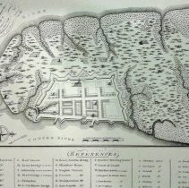
Map - A Plan of Charles Town, from a Survey of Edward Crisp in 1704, Engraved by James Akins
Reproduction of a survey of Edward Crisp in 1704 featuring the land on the Charleston peninsula land and the fortified city, a/k/a "Walled City." Includes references (index) to notable buildings and other features. Reproduced in 1969 by Historic Urban Plans ... from the original in the Cornell University Library. Digitized map available from Library of Congress Digital Collecitons at https://www.loc.gov/maps/?fa=contributor:crisp,+edw&q=cri...
Record Type: Archive
-
Map - Plan for Fortifying Charles Town, South Carolina
Photographic reprint of DeBrahm's July 1757 "Plan for Fortifying Charles Town, South Carolina, as Now Doing, with Additions and Improvements." Shows the fortification wall surrounding the City [Walled City]. Includes references to points of interest. Source of original map not indicated.
Record Type: Archive

-
Map - Plan of a Project to Fortifie [sic] Charles Town
Color photocopy of De Brahm's "Plan for a Project to Fortify Charles Town, Done by Desire of his Excellency The Gouvernour in Council, by William De Brahm, Captain, Ingineer [sic], in the Service of His Late Imp Maj. Charles VII." Copied on two pages, showing the fortification wall surrounding the City [Walled City] (first page), including a northern fortification (second page). This plan was rejected because of the exorbitant cost and his later ...
Record Type: Archive

-
Map - Home Ownership Program Status on Coming and Warren Streets
Map depicting the status of buildings in the neighborhood of Coming Street (140 block) and Warren Street (50 block), likely documentation of HCF's Homeownership Program. Color-coded to reflect: Dark blue=existing housing stock to be saved through relocation Red=houses destined for demolition to be relocated Orange=existing structures that were to be demolished Aqua=new construction [Charleston Housing Authority] Green=mature trees to be lo...
Record Type: Archive
-
Plan, Landscape (Garden) - Waterfront Park [Landscape Plan]
Map/landscape plan of Waterfront Park possibly created after the publication of the Charleston Waterfront Park Master Plan. Creator of original map not indicated. It has been hand-colored by Historic Charleston Foundation. Shows the area bounded by South Adger's Wharf, East Bay Street, Market Street, and the Cooper River, with building footprints. Indicates "Existing Uses": Pilot House, Exchange buildings, Perdita's, Carolina Shipping, Luden'...
Record Type: Archive

-
Map - A Sketch of the Operations before Charleston, the Capital of South Carolina
A Sketch of the Operations before Charleston, the Capital of South Carolina, 1780. "Charleston having surrendered by capitulation the 12th of May, the garrison laid down their arms at I, between the abbatis in front of the hornwork." Table of references identifies features and details of the Siege including fortifications. Ships in the harbor also identified. Print of an original map by Abernethie.
Record Type: Archive

-
Map - Map of American Defenses During the Siege of Charleston
Reproduction of a map done by a volunteer with the American forces showing the American defenses during the Siege of Charleston in 1780. Distinguishing feature is the "horn work" at the upper center of the map. Possibly reproduced by the Cincinnati Society. Original map in the Yale Univrsity Library.
Record Type: Archive

-
Calendar - Charleston, S.C. Souvenir Calendar 1902
Souvenir calendar of Charleston, illustrated with a captioned photograph of a building for each month. Includes six additional pages featuring photographs of buildings, statues, and other landmarks. Cover: St. Michael's Church January: The Old Exchange February: Charleston College [Randolph Hall] March: Marion Square [Citadel, St. Matthews German Lutheran Church] April: Thomson Auditorium May: Orphan House June: Market Hall July: "Dom...
Record Type: Archive

-
Map - Map of the Seat of War in South Carolina and Georgia
Reproduction of the 1861 Map of the Seat of War in South Carolina and Georgia, published and lithographed by Evans & Cogswell. Shows the coastal area from Georgetown, South Carolina, to Savannah, Georgia, and territory inland as far north as Kingstree, South Carolina, to Orangeburg, South Carolina. Gives the location of forts and shows coastal shoals, drainage, roads, railroads, ferries, bridges, dwellings with names of inhabitants, churches, and...
Record Type: Archive

-
Property File - 1-11 Ashley Boulevard
A two-story apartment building constructed ca. 1920, demolished in 2019 due to structural problems with the foundation and the walls that proved unsalvageable. No additional history available. Needs further research. File contains structural report (Applied Building Sciences); newspaper article about the demolition; Sanborn maps (1944, 1951, 1955).
Record Type: Archive

-
Property File - 7 Gibbes Street
Likely constructed in the first decade of the 20th century, 7 Gibbes is a two-story wood frame residential structure resting on a masonry foundation. File contains graduate student report (Darcy Neufeld, 2019) on the history of the house, which includes historical and chain-of-title research, maps, photos, and other supporting documentation.
Record Type: Archive

-
Property File - 20 Water Street
20 Water Street is a two-story, five-bay structurally originally of brick construction, situated on an "L" shaped lot. File contains graduate student report (Bernard O'Brien, 2019) on the history of the house, which includes historical and chain-of-title research, maps, photos, and other supporting documentation. Image in this record from document in property file; no other images on file.
Record Type: Archive
