


Archive Record
Images
Metadata
Object Type |
Map |
Title |
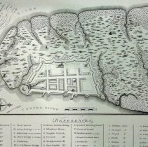
A Plan of Charles Town, from a Survey of Edward Crisp in 1704, Engraved by James Akins |
Scope & Content |
Reproduction of a survey of Edward Crisp in 1704 featuring the land on the Charleston peninsula land and the fortified city, a/k/a "Walled City." Includes references (index) to notable buildings and other features. Reproduced in 1969 by Historic Urban Plans ... from the original in the Cornell University Library. Digitized map available from Library of Congress Digital Collecitons at https://www.loc.gov/maps/?fa=contributor:crisp,+edw&q=crisp. |
Creator/Author |
Crisp, Edw. (Edward) |
Date |
1704 (date of original) |
Subjects |
Charleston (S.C.)--Maps |
Search Terms |
Historic maps of Charleston Wall Street |
Physical Description |
Reproduction of original map, 13" x 15" |
Object ID # |
2019.001.14 |