Photos
Photo Results
42 results found sorted by relevance. Records searched: 4078
-
City Hall, Charleston, S.C. - ca. 1905
Photographic postcard featuring City Hall and the corner of Broad and Meeting Streets. Fireproof Building (101 Meeting Street) can be seen at left. Pedestrians are on the sidewalk and street. Produced by the Rotograph Company.
Record Type: Photo

-
King Street North of Beaufain Street - ca. 1953
Photographic postcard featuring King Street looking north from just below Beaufain Street (mid-240 block) and beyond. The three buildings at the lower right were demolished for the construction of Charleston Place. Cars on the street; pedestrians on the sidewalk. Back of postcard is postmarked October 13, 1953, and has a three-cent postage stamp. Captioned: "King Street - main retail district of Charleston, S.C., looking north from Beaufain St...
Record Type: Photo

-
Post Office and St. Michael's Church, Charleston, S.C. - early 20th c.
Postcard featuring the south elevation of the U.S. Courthouse and Post Office, and St. Michael's Church. Landscaped grounds in foreground where an annex was constructed in the late 1980s. Published by the Detroit Publishing Co. Postcard number 70258.
Record Type: Photo

-
Charleston, S.C., Battalion at S.C.M.A. [South Carolina Military Academy] - early 20th c.
Postcard featuring a battalion in formation on the parade grounds of the South Carolina Military Academy, now Marion Square. View looking east toward Meeting Street. Old hornwork fragment can be seen at left; Calhoun Monument at right. Published by the Hugh C. Leighton Co.
Record Type: Photo

-
The Roper Hospital, Charleston, S.C. - early 20th c.
Photographic postcard featuring the old Roper Hospital, located at the corner of Calhoun and Lucas Streets. Postcard numbered A12596.
Record Type: Photo

-
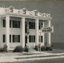
Colonial Motor Court [142 Cannon Street] - 1960s?
B&W photographic postcard featuring The Colonial Motor Court which had been located at 142 Cannon Street. On verso: "Colonial Motor Court. Tile bath and shower in every room. Wall to wall carpet. Air-cooled and steam heat. 142 Cannon Street. On route 17 in the city. I.G. Beach, Manager and Owner." Published by Nelson's Southern Printing. There's no history on this building in HCF's Archives. What is known is that it was located on nort...
Record Type: Photo
-
The Lake from the Band Stand, Charleston, S.C. - ca. 1900
Postcard featuring a view of the lake in Hampton Park from the band stand.
Record Type: Photo

-
Scene in Hampton Park, Charleston, S.C. - ca. 1914
Postcard featuring a view of Hampton Park. Back is postmarked April 28, 1914, and has a one-cent stamp.
Record Type: Photo

-
First Scotch Presbyterian Church, Charleston, S.C. - ca. 1940
Photographic postcard of First Scot's Presbyterian Church (57 Meeting Street), showing the northeast corner of the building and the corner of Meeting and Tradd Streets. Cars parked in front. Street light in foreground.
Record Type: Photo

-
East Bay Street, Charleston, S.C. - 1895
Copy of a photograph mounted on paper featuring the houses on the west side of East Bay Street from 43 East Bay to near Tradd Street. The most discernible buildings are 43 East Bay, 45 East Bay, 47 East Bay, 51 East Bay, 53 East Bay, 55 East Bay, 57 East Bay, and 59 East Bay. Two pedestrians stand in front of 47 East Bay. Trolly car in the background at right. Captioned "East Bay Street, Charleston, S.C., 1895."
Record Type: Photo

-
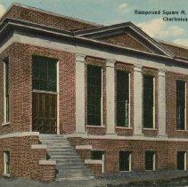
Hampstead Square M.E. Church (South) - ca. 1913
Postcard featuring Hampstead Square M.E. Church [South], built in 1912, located at the northwest corner of America Street and North Hampstead Square. (Charleston County identifies the address as 0 North Hampstead.) A portion of the north elevation of 79 America Street is seen at right. Back of postcard is postmarked April 22, 1913, and has a one-cent postage stamp.
Record Type: Photo
-
James S. Gibbes Memorial Art Gallery - ca. 1908
Postcard featuring the James S. Gibbes Memorial Art Gallery, around three years after it was built [135 Meeting Street]. Two men stand on the street in front of the building. Neighborhing buildings also in view on either side. Back of postcard is postmarked March 6, 1908, and has a one-cent postage stamp. Published by the Hush C. Leighton Company, Manufacturers, Portland, Maine.
Record Type: Photo

-
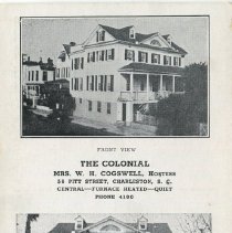
56 Pitt Street - Undated
Photographic postcard featuring 56 Pitt Street, "The Colonial," when it was operated as a guest house. Features two photographic views of the building -- front and side. Captioned: "The Colonial, Mrs. W.H. Cogswell, Hostess, 56 Pitt Street, Charleston, S.C. Central - Furnace Heated - Quiet. Phone 4180." Photograph caption: "Built about 1790. Cogswell residence since 1871." On verso is a small photograph of the sign: "The Colonial - Tou...
Record Type: Photo
-
The Pink House - ca. 1939
B&W photographic postcard of The Pink House at 17 Chalmers Street and neighboring buildings on either side, including 13-15 Chalmers, now a parking lot. On verso: "The Pink House. A pre-Revolutionary tavern unique not only for its color but also because it is three stories high and has but one room to a floor." Back is postmarked August 18, 1939 and has one-cent stamp. "Whitman's Prototypes."
Record Type: Photo

-
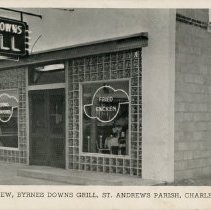
Exterior View, Byrnes Downs Grill, St. Andrews Parish, Charleston, S.C. - ca. 1950
Photographic postcard of Byrnes Downs Grill. On verso: "Byrnes Downs, named in honor of former Secretary of State James F. Byrnes, a native South Carolinian. Byrnes Down Grill located on highway 17 at intersection highway 61, 1 mile West of Ashley River Bridge, Charleston, South Carolina. Specializing in southern fried chicken, fried chicken, western steaks and fresh Charleston seafoods." Address was 173-B Savannah Highway. Published by...
Record Type: Photo